If any of you have the chance to visit Central Australia, do yourself a big favour and take a trip out to Palm Valley. The valley is a place that time has forgotten, a magnificent piece of God’s handiwork on display. Due to the recent rain in Alice Springs the Finke River had plenty of water in it, and the road to the valley had been closed for a few days. I am glad we were not in our 4WD, I would have been so scared having to cross the rivers, and then trying to make our way up onto the slippery banks. On my last trip, the tour only went as far as walking alongside the river bed and then returning. There is now a ridge top walk, which the three of us did, an easy walk with a few stairs to ease the way now and again. I am glad we decided to start the walk at the beginning of the valley, because, at the other end there is a very steep set of stairs, which we would have had to have climbed if we commenced the walk from there! It was so much easier for us ‘oldies’ to climb down them! The views across to the other side of the ridge and down to the river were spectacular, especially being able to see the Livingstonia Palms from above. These palms are the same type around in the days of the Dinosaurs. By the end of the walk, I was starting to lag a bit, and Mags was also struggling as her bad foot was giving her heaps. By the time we reached the shelter we were well and truly ready for our lunch.
Friday, October 8, 2010

Emily Creek Big Hole, NT (23 June, 2010)
There are many beautiful gorges around Alice Springs, in the East and West MacDonnell Ranges, one of the most beautiful is Ellery Creek Big Hole. I will let the pictures tell the story.

Standley Chasm, NT (23 June 2010)
Standley Chasm is on the must see list of most tourists to Alice Springs.
The path into the chasm is very, very rocky, and one needs to be fairly agile, the creek bed is made up of large rocks and boulders, and it can be dangerous if one is not careful. There is a warning sign at the start of the track, it says the walk it is 'easy but rocky'... Hmm.. think they need to revise that, the sign is misleading, and the path can be very difficult; we actually met up with an older women who was using her 3 pronged walking stick! I don't know how she did it, at least there was a person to help her along. Mags, Bucko & myself, took it slowly and stopped to admire the scenery on the way through, we were in no hurry as we had given ourselves plenty of time to reach the Chasm. A group of high school students were on a mission, which I think may have been, to see how quickly they could get to the end of the track. At noon the sun is overhead and shines down into the small chasm to light up the sheer high walls, and turn them the colour of gold. The walk was worth it. Take a look at some of the photos, and you will see plenty of people hanging around for the sun to arrive. The show is over very quickly and the place cleared out in a matter of minutes. At last we had the chasm to ourselves and so, enjoyed the cool shade and the peacefulness. Arriving back at the car we sat down for a much needed rest and ate our lunch in the shade of the trees. Many travellers where having their lunch near us, and it was not long before I was chatting to them; asking the Traveller Trifecta ''where are you from? where have you been?, where are you going?" - (I can hear you both cracking up from here, C&T, and yes, someone did ask us "is it worth it?").
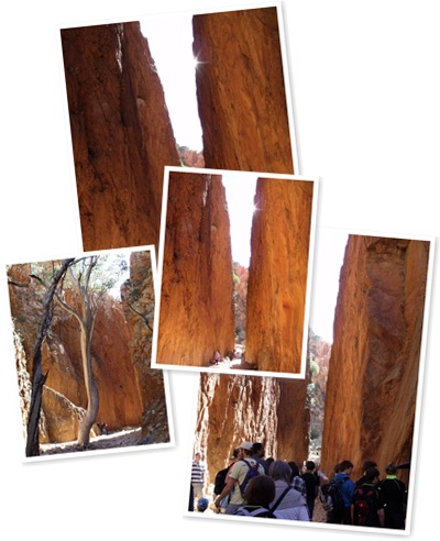
The path into the chasm is very, very rocky, and one needs to be fairly agile, the creek bed is made up of large rocks and boulders, and it can be dangerous if one is not careful. There is a warning sign at the start of the track, it says the walk it is 'easy but rocky'... Hmm.. think they need to revise that, the sign is misleading, and the path can be very difficult; we actually met up with an older women who was using her 3 pronged walking stick! I don't know how she did it, at least there was a person to help her along. Mags, Bucko & myself, took it slowly and stopped to admire the scenery on the way through, we were in no hurry as we had given ourselves plenty of time to reach the Chasm. A group of high school students were on a mission, which I think may have been, to see how quickly they could get to the end of the track. At noon the sun is overhead and shines down into the small chasm to light up the sheer high walls, and turn them the colour of gold. The walk was worth it. Take a look at some of the photos, and you will see plenty of people hanging around for the sun to arrive. The show is over very quickly and the place cleared out in a matter of minutes. At last we had the chasm to ourselves and so, enjoyed the cool shade and the peacefulness. Arriving back at the car we sat down for a much needed rest and ate our lunch in the shade of the trees. Many travellers where having their lunch near us, and it was not long before I was chatting to them; asking the Traveller Trifecta ''where are you from? where have you been?, where are you going?" - (I can hear you both cracking up from here, C&T, and yes, someone did ask us "is it worth it?").
Simpsons Gap, NT (23 June, 2010)
Simpson Gap is the first gorge that is on the Larapinta Drive out of Alice Springs. Due to the heavy rains in Alice Springs, while we were there, the gorge had plenty of water in it so we could not go further into the Gap, nevertheless, it was a pretty place to visit. Enjoy.
My sister Mags took these photos with the camera she bought while in Alice Springs; nearly every picture she took while on her holiday with us came out extremely well. Considering Mags is not used to using a camera, I am very proud of her and the photos she has taken. Thanks Mags.

My sister Mags took these photos with the camera she bought while in Alice Springs; nearly every picture she took while on her holiday with us came out extremely well. Considering Mags is not used to using a camera, I am very proud of her and the photos she has taken. Thanks Mags.
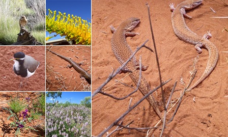
Alice Springs Desert Park, NT (22 June, 2010)
Alice Springs Desert Park is set out in sections to display the plants, earth and fauna of the different types of land in Central Australia.
The walk around the park is an easy one, with free audio commentary, which explains the different eco systems. An active display of wild native birds, was a highlight of our visit to the park; it was terrific being able to see up close, many of the birds that we have seen during our travels. As the birds move SO fast, Mags and I were unable to get any photos except for an Owl, however, I hope you enjoy the pictures of flowers, goannas and birds from the park.
The walk around the park is an easy one, with free audio commentary, which explains the different eco systems. An active display of wild native birds, was a highlight of our visit to the park; it was terrific being able to see up close, many of the birds that we have seen during our travels. As the birds move SO fast, Mags and I were unable to get any photos except for an Owl, however, I hope you enjoy the pictures of flowers, goannas and birds from the park.
Road back to Alice - The Undie Tree (19 June, 2010)
The return trip to Alice Springs is backtracking via the only bitumen road (Luritja & Lasseter) into and out of the area. There is talk of sealing the (4WD only track) of the Ernest Giles road (see map), to cut down the time taken to get from Alice to Kings Creek, then onto Yulara. Talk is talk, and it has been happening for years, so who know when the bitumen road will actually exist. The only safe road for tourists to travel (unless they have a very good off road car and or caravan), is the long way round!


Kings Canyon, NT (17-18 June, 2010)
Our next stop after Yulara was the campground at Kings Creek Station, a working cattle station near Kings Canyon. To get to Kings Creek Station from Yulara we had to travel back along the Lasseter Highway, then turn left onto the Luritja road which lead to the station. Trivia Time: what is the difference between a Canyon and a Gorge? Answer is at the bottom of this posting. The campgrounds are rustic and very appealing; red earth, covered BBQ area, deep fire pits with stone surrounds, plenty of shade trees, large clean shower cubicles and even a swimming pool. To use the one and only (fairly new) washing machine, the cost is a voluntary gold coin donation to The Royal Flying Doctor Service, a fantastic idea. The machine sits in a tiny outdoor, undercover setting in the grounds. The Station has quad bikes for hire, camel rides and helicopter flights, Sadly, (for the staff of the station), when we were there a long term employee (of the Station) had died, and most of the staff were off in Alice Springs attending the funeral, so no rides were available, which did not worry us.
I was fortunate to be able to climb the rugged path up to the top of Kings Canon when I was there 30 years go, but, old age has caught up with me! My Bursitis (which affects my knee and hip) was giving me heck and Mags could hardly walk because a problem with her foot and back; which left Bucko as the only one who was fit enough to do the climb, however, he decided to stay at the base with us and do the creek walk. What a sweetheart. The creek walk is stunning, it takes about 1 hour, following the path of the creek, which wends its way through huge magnificent Red River Gums, huge fallen Mereenie Sandstone rocks, (the last major rock fall was in the 1930s), surrounded by towering walls of red rock, ending at a deep, dark emerald/jade green waterhole. From the Creek Walk we could look up and see people who had done the climb looking down at us. I feel very lucky to have been able to see both sides of this wonderful part of the outback.
One Friday morning (18th) we drove up to the Kings Creek Resort to take a trip in a helicopter, Mags had never been in one, so it was all very exciting for her. The flight took us over Kings Canyon and to the area behind the canyon, which is like a pound; high walls, surrounding flat grazing land with a creek flowing through, the creek flows into Kathleen Springs, which is in Kathleen Gorge. A lone camel could be seen wandering around, below the helicopter.
Trivia Answer: Gorge is an English word and Canyon is American, both mean the same thing!

Mt Conner NT, Afternoon/Evening trip (15 June, 2010)
On the road to Yulara, there is a huge flat topped, rock like formation, tour guides tease tourists with this sight, "oh, can anyone see Uluru", or "what is that.," I have heard these words myself, on my trip 30 years ago, everyone of the bus went "ooh" and wanted the driver to stop the bus. Amongst the tourist trade Mt Conner is referred to as 'Fooluru'. Mags mentioned she would like to go out to Mt Conner, and I said "they don't do tours out there". The good news was, tours are now available to view Mt Conner at sunset, followed by a BBQ meal at the Curtain Springs Station Roadhouse. Mt Conner is owned by Curtain Springs Station.
The rough dirt road through Curtain Spring Station was the original route from Alice Springs to Ayers Rock, (as it was named in the 'old days'), and it would have been a rugged, hot and tiring ride, which took a week! One of the over night stops for travellers, was at Curtain Springs Station, the following day they would be on the rough, dirty, rocky road for the next leg to The Rock. Our trip from Alice Springs to Uluru took 5 hours, on a great bitumen road all the way. The day trip from Yulara Resort to Mt Conner was in an air conditioned 4Wheel Drive (SUV). Along the route we stopped off at a salt lake which is on the station. Large clumps of pale pink salt can be found sitting on the top of the lake; me being the questioning person I am asked "what makes the salt pink?' Neither of the two guides knew. I wonder if they did a search on Google to find an answer, or maybe one of you can tell me?
Spotted wild camels wandering about, these were quickly reported to the Station Owner as they are classed as feral animals, which compete with the cattle for food and water, as well as damaging fences. In the harsh and dry climate of Central Australia, water is precious commodity, so, camels are shot on sight. The Camel population (in Australia), is greater than in the Middle East; if a camel is lucky, they may be captured and shipped off to Arabia to become a racing camel or as breeding stock to refresh the blood lines. The Camels in Australia have a pure blood line, and are strong and healthy as they have been wandering free for the past 100 years. Camel meat is also sold in The Territory, and the taste is a cross between Beef and Mutton.
Mt Conner is actually the same size as Uluru, but 1 metre lower,some of the staff from the Station have built a cairn at the tope to bring the height up to match Uluru. There is a VERY rugged track up the eastern side of Mt Conner which we drove up, to about half way. The view is wonderful and most of us had a bit of fun playing around at pretending to fall off the side of the mountain, me included of course! Those who know me well, know I am a big kid at heart!

Kata Tjuta, NT (14 and 15 June, 2010)
One of the must see sights in Central Australia are the HUGE domes like structures which make up Kata Tjuta. I so enjoyed my visit to them 30 years ago, of course the facilities for travellers is so much better than then, now there are safe walking paths, bathroom facilities, picnic areas, with gas free gas BBQs etc.

After doing the morning the Mala Walk, at Uluru, we drove out to see Kata Tjuta, a trip of approximately 45kms, with a number of viewing sites along the way. We decided to make our first stop the Kata Tjuta sunrise viewing platform.
The flies were out in force, so Mags and I donned our glamorous headwear of black fly mesh. Many comments were made by passers by on our walk to the platform, all along the lines of how they 'wish they had one of those, and to heck with how it looks'. Mags ands I were not worried about how we looked, at least there were no flies on us!
One evening we went out to view the sunset at Kata Tjuta, nibblies and drinks in hand of course, this time we had to take our small camping seats with us, and as the viewing site was not near the car park, this was no effort. We settled in for the show, which is a second cousin to the display at Uluru, however, it is still impressive and we enjoyed it.
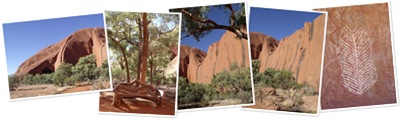
Uluru, NT (12 - 16 June, 2010
The day before we left the Alice for our trip out to see Uluru and Kata Tjuta (previously named Ayers Rock and The Olgas) was spent shopping in preparation for our stay at the Yulara Campground; we had been told everything was more expensive out there, so we stocked up on fresh salad items and fruit etc.
The trip to 'The Rock' takes about 5 hours with a van, so Saturday morning, (12th), we were up and breakfasted early for a quick getaway. With Mags being an experienced hand at tent camping, it did not take us long to pull down and pack up the annexe, the caravan had been made ready the day before. The halfway point to 'The Rock' is the Erldunda Roadhouse on the Stuart Highway, so this was where we stopped for lunch, and topped the car up with petrol, which at $1.79 per litre; was the most expensive price we had paid so for on our trip, still, we had to have it.
The campground at Yulara is the closest one to the Uluru-Kata Tjuta National Park, (there is a VERY basic campground at the Curtain Springs Station Roadhouse, but this is 78kms away), we had booked for five nights to give us plenty of time to see the park.
After setting up the van and annexe we took off to have nibblies out at Uluru. Thirty years ago, when I last was out at Uluru, the viewing sites were all over the place, tourist coach passengers and independent travellers, jostled for space to get the best view, at times the language was very heated; when someone's head appeared in the view finder of folk's cameras. Today, it is all very civilised, with separate viewing areas for Coaches and cars, we found a spot to view the Sunset, opened up the back of the Land Cruiser and sat on the tailgate, with drinks and nibblies set out, and waited for te sun to set.
The next four days, we went in and out of the park many times, we could also most travel the road blindfolded! One of our visits was to The Aboriginal Cultural Centre, which is excellent, a few hours were spent there learning about the dreaming stories and how the people lived in this area for 50-60 thousand years. I have never climbed Uluru as I respect the request of the Owners to not do so, Bucko is of the same view as me, and I think Mags took one look at the climb, which was closed, due to high winds, and was happy the decision was taken out of her hands! We drove around Uluru instead, as well as walked The Mala Track.

Subscribe to:
Posts (Atom)