Showing posts with label SA. Show all posts

Monday, September 6, 2010

Coober Pedy - Mad Max country - SA (28 May - 3 June 2010)

After leaving Woomera we continued on up the middle, next stop was Coober Pedy, where the Mel Gibson movies, of Mad Max were filmed.  Coober Pedy is famous for the wonderful colourful opal mined here, as well as for under ground homes and Churches.  The trip from Woomera to Coober Pedy is the longest stretch on the Stuart Highway without fuel stations.  A lesson was learned on this stretch - always top up with petrol when one has the opportunity!   We speak from experience; about 80kms out from Coober Pedy we noticed the fuel gauge was getting rather low, so slowly, slowly, the speedo started to descend, until we limped into the town (along with 6 other vehicles) and made a bee-line for the first petrol station.  A very strong head-wind played havoc with our fuel consumption, and as it turned out, we had 30 litres to spare.  Never again have we gone past a petrol station without topping up! The locals must have a laugh to see all the different vehicles limping into town.
When in the caravan park at Coober Pedy, I mentioned to a lady we were staying 5 days, talk about shock, horror, the response to my comment was,  "Five days in Coober Pedy, what is there to do?"  I am sure you will be able to see from our list below, there is more than enough to do for many days stay in Coober Pedy. We had a great time, and Bucko had a delicious 'Coat of Arms' pizza in the best food shop in town, 'Johhnos', spotlessly clean, incuding the front and back counter space, along with great service, food and coffee.  Coober Pedy is a very unusual town, the streets are dry and dusty, nearly all the front yards look like garbage dumps, took me a while to figure out why - doh!  No backyards to hide the unwanted cars, tyres, pipes and the general rubbish in, so, of course they all sit out the front.  General decorations around the town are old used tyres; they are used as retaining walls, garden beds, you name, the folk of Coober Pedy have come up with a way to recycle the tyres.  All in all, we enjoyed are time in this rustic town very much, a few photos from around the town are in the album below.
After a look around town and the usual visit to the Information Centre, we decided to extend our stay from 3 to 5 nights, there was so much we wanted to do! Amongst the list was:
  • Take a 4hr flight to view Lake Eyre, with water in it, and stop over for lunch at William Creek, an iconic Outback Pub, which was once a stop on the old Ghan Railway line, total population 6!  Fantastic food, prepared by the lady who started the "Road Kill" menu at Parachilna in the Flinders Ranges. 
  • Ride with the Postman (and 12 others), on the 12hr mail run to out back stations. Lunch was at William Creek, we were almost locals, 2 days in a row we had been there for lunch.  Dinner was at the Pink Roadhouse at Oodnadatta.  Stations we stopped at along the way included Anna Creek, at 34,000sq kms the largest in the world - and the size of Belgium!  The photo album includes a photo of the mailman, who is an very interesting man, we learnt heaps, about the area and the brave explorers who ventured into the outback.  A special stop for myself and Bucko, (we both adore anything to do with Trains), was at the old iron railway bridge; which was part of the old Ghan rail track.  The powers that be, decided to pull down the bridge, however, the locals kicked up a bit of a ruckus and the bridge still stands. No welding was used in the bridge, only steel rivets, and the bridge has withstood many very high floods, as high at the railway lines, running through it.  More info: Mailrun Tour
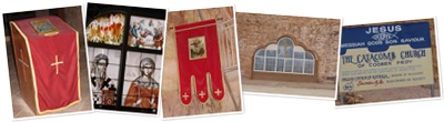
  • Visit Underground Churches and Fays House. Our pick of the churches is the Serbian Church, a true underground church. On opening the door, one has to walk down and down a cool corridor, with walls of sealed stone, to then turn left into the main chamber of the church.  Unfortunately, due to cost savings some of the lights were not working, so the wonderful painted windows did not show up well in the photos I took; still we liked the place.  Fays' house, is like time has stood still and we had stepped back into the 60s.  A condition of sale, when Fay sold up, was for the house to be kept as a living museum, and it is, a lovely cool house to live in.  On those extra hot days that they get in Coober Pedy, a swimming pool is just outside the underground house, clean and ready for a quick dip, all under the cover of a roof and with shade cloth walls.  Ah, the best of both worlds. 
  • Visit the Old Timers Mine, this is an old abandoned mine which was accidently  discovered when the owners decide to dig out another room, for one of their children.  Instead of digging into solid rock, suddenly a hole appeared, and there was the old mine, just as the old miners had left it, many years ago.  The good news for the new owners was, the wall they broke through actually had a good seam of opal in it. I would not have liked to have been a miner in the old days, scary stuff in those terrible cramped and dusty conditions, see the 'models' below!. Come to think of it, not much different nowadays - thinking of those miners in Sth America.  More Info: Old Timers Mine  
                                  IMG_7313          IMG_7314
  • Tour a working Opal mine, now, this was very interesting, the young women who showed us around worked in partnership with her Dad; her young son, was scampering around the mine, just like any child would do in their own back yard!  A demonstration was given on how to make the explosives, used to break up the rock - they look just like a giant firecracker.  A sad tale we were told was, when a friend of the young women turned 21yrs, there was a party up above one of the mines.  The Birthday boy went down to set up a 21 bang salute, then came back up to view the fireworks, oops, the last one did not go off, so back down the mine he went to see what had happened..... a complete NO, NO, the poor lad was killed when the explosive went off.  Talking about dust, the demonstration given to us, was all done with the miner in a very confined space, drilling with the jack hammer, type of machinery and with NO mask.  All the folk on the tour gasped, and asked about masks, the response was"yeah, I am meant to wear one, but, they get too hot etc etc."  All I could think of of was how her lungs could be sucking in all that damaging dust.  Us city folk are so conscious of work safety, and out in some of the bush areas it seems it is all to hard.     
                   IMG_7870      IMG_7871 
  • Visit The Breakaways, most people who come to Coober Pedy do so, to see the opal mines, a few dugouts and usually only stay a night or two.  What a wonderful landscape they are missing out on, The Breakaways.  See for yourself.                                                          IMG_7740              IMG_7741 
  • Take a trip to the Dog Fence, a fence of legend, which is really just a fence, but, we had to see it.  For my  international readers, you may be asking, "What is the Dog Fence?  "The Dog Fence is a pest-exclusion fence that was built in Australia during the 1880s and finished in 1885, to keep dingoes out of the relatively fertile south-east part of the continent (where they had largely been exterminated) and protect the sheep flocks of southern Queensland. It is one of the longest structures in the world and is the world's longest fence. It stretches 5,614 km (3,488 mi). (Ref: Wikipedia). The only native dog in Australia is the Dingo, who just loves to hunt sheep.
                             IMG_7723        IMG_7721
  • Purchase a book 'The Last of The Nomads' which is about Warri and Yatungka who were believed to be the last members of the LASTNOMADSMandildjara tribe, of the desert nomads to live permanently in the traditional way. This book is a real eye-opener on how strong and resilient the Aboriginal people were, to be able to live and survive for thousands of years in such a hostile and harsh land.  Do yourself a favour and borrow the book from your local library, or better still, purchase it for yourself, this book is a 'keeper.'  To purchase follow this link The Last of The Nomads.
I hope you enjoy reading this posting; why not leave us a comment, go on, be brave, it is so easy to do. Just click on the word Comment and follow the instructions.  Don't forget to sign your name to the comment, so Paul & I know who you are. (smile)

Up the middle, on the Stuart Highway - Woomera - SA (27 May 2010)

After our wonderful adventure in The Flinders Ranges, it was back down to Port Augusta for a couple more nights, to stock up on groceries and do the washing, before we set off up 'The Middle'.
We left Port Augusta on the 27th of May.  To begin with the weather was dull and grey, and we felt a tad sad to be leaving views of the Flinders Ranges behind us; about 15mins out of the town, the rain came bucketing down, all smack bang into our windscreen.  It was rather difficult to see at times, and we were just glad we did not meet up with any Road Trains going down to Port Augusta. The rains topped and then a very strong headwind took over!
Woomera, was a stop over on our way to Coober Pedy; Paul & I had wanted to stay here so we could look at the old rockets used on the Woomera Rocket Range.  The camp ground is vey small, with clean pre-fabricated ablution blocks.  The lady on reception was friendly and gave us a map to the town and the sites.  As soon as we had settled in, we did our usual and took off for a drive around town, this did not take very long! I could feel spirits of old about the place, and the town seems to have a sad are about it.  The supermarket was HUGE with very wide aisles between each section, a left over from the days when the town was full to capacity, with Defence Department personnel, who worked on the rocket range. The Defence Department still maintain a small presence in the town, which most likely keeps it going.  The rockets intrigued us, so here are a few pics to share with all those who are old enough to conjure up visions of rockets, when ever Woomera is mentioned!  Enjoy.
To see the photographs, click on the link - View Full Album

Sunday, August 1, 2010

Flinders Ranges - SA (12 - 26 May 2010)

Port Augusta : Our trip from Burra to The Flinders Ranges was via Port Augusta, at the head of the Spencer Gulf in SA.  Port Augusta is where five roads converge, (commonly known as The Five Ways), West to Perth, North to Darwin, North-East to Broken Hill and New South Wales, South-East to Adelaide and Melbourne, and South-West to the Eyre Peninsula, SA.  Port Augusta is a seaport with a natural harbour, which was settled on 24 May 1852 by Alexander Elder and John Grainger. The port was named after Augusta Sophia, Lady Young, the wife of the Governor of South Australia, Sir Henry Edward Fox Young. A railway junction city, Port Augusta is a stop on the Indian Pacific trans-continental train service on the Sydney–Perth railway and on the Ghan service between Adelaide, Alice Springs and Darwin.  Most travellers use Port Augusta as a stop-over enroute to other parts of Australia, a quick shop to stock up on food items, do the washing in water other than brown bore water, then on their way again.  Bucko and I were no different, we did however visit the Wadlata Outback Centre, attached to the Information Centre, which provided us with an introduction to life in the Australian outback.  The Wadlata Outback Centre is well worth a visit. Ref: Wadlata Outback Centre and Port Augusta Council

Rawnsley Park Station : We had booked to stay at the caravan park at Rawnsley Park Station (RPS) for 3 nights, however, in the end we extended our stay to 11 nights.  There is so much to see in The Flinders Ranges, including WiIpena Pound, a natural rock formation resulting from millions of years of erosion, and many picturesque and ancient Gorges.  Rawnsley Park is in an isolated part of the Flinders Ranges, and as such has only satellite communications (Phone, TV and Internet) to the rest of the world including Australia.  The high walls of Wilpena Pound blocked standard communications from getting into the Park, and surrounding areas, hence the reason for many folk driving to The Pound to make mobile calls, or to use their lap-tops.  Bucko and I were amongst those people, we made a few calls out to family and friends when we where up visiting The Pound.
From RPS we were out and about nearly every day, of course it did rain the day we arrived and the day we left, we are The Rainmakers after all! Listed below are some of the many wonderful sights etc, that we saw in our travels around The Flinders.IMG_1626

a plane flight from RPS took us over Wilpena Pound, and the Ranges, a beautiful sight. A hazy start to the day soon cleared, and we were able to see the Ranges in a soft golden light. 

Glass Gorge, I drove off road, along an ancient and rugged river bed, through stunning Glass Gorge, where (while I was driving), we spotted a rare Red Footed Wallaby, who scampered off, up the side of the road before I could get a photo.  IMG_6486I was however able to take a picture of a Grey Wallaby, this creature was not shy at all, and did not even move as the car crept slowly along beside her, and her Joey. The track to Glass Gorge runs north from Blinman and is  the original route for drays delivering copper to the railway at Parachilna, it is a pretty rugged road, so I would not like to have been a bullock driver in those days!

Parachilna Road House with it's menu of 'Road Kill' - Kangaroo, Emu etc was a very interesting place, the roadhouse 'sits' right beside the railway and with overflow accommodation (from the Hotel), in old Shipping Containers'.  If we had stayed until the evening,  we would have been able to sit on a bench outside the pub, to watch the coal train returning from Leigh Creek (in the North), roll on by on its way to the power station at Port Augusta. The train consists of some 180 trucks, 3 km in length, and takes about 5 minutes to pass.

A walk into Wilpena Pound, took us to where the original station farmhouse, which belonged to the Hill Family, still stands; along with a few items used on the station.  The walk in is along boardwalks (which are over the river), and rough paths, along the way we came across a few Wallabies just doing their thing, they didn't even look at us humans!  There is now a Heritage Protection on the area surrounding the old house. 
The Hills Homestead (12)    Sliding Rock Wilpena Pound (1)      
A steep rocky climb behind the house, took us to a platform from where we could view the Pound, which appears to be a real oasis.  The river runs into the Pound, but looks can be deceiving, the place was no good for  farming, too dry, and then floods would come and wash away the pathway into the Pound, making it far too difficult to take goods in and out. In the end the family went back to Adelaide and gave up the farm.  The path was cut out by the family themselves, and it is not until we saw it with our own eyes, that we appreciated what a hard life the early famers had. The photo above is of Sliding Rock, which sits almost (in this section) on a very narrow path into the Pound. 

Arkaroo Rock , an important Aboriginal art site in the Flinders Ranges features ochre and charcoal images depicting the creation of Wilpena Pound.  The circuit walk to the cave drawings was so beautiful, a bit rocky, but well worth the climb. We met a friendly traveller, on his way back down, who advised us to "take the path to the left when you get to the fork in the road, as it was much easier to climb".  Good advice.    IMG_6585     IMG_6597     
IMG_6615
The trip back down was much rockier, and the view more spectacular than the path upwards; at times we felt we could almost reach out and touch to huge rocky outcrops to our right.

Sacred Canyon, a small chasm where ancient Aboriginal rock engravings are found on sandsIMG_6731tone walls, however the carvings were very hard to photograph, so we took none.  At the end of the chasm was a very high rock wall, with a THIN ledge, Bucko climbed the wall, then came back to tell me "if you don't come come up here, you will be disappointed, there is a massive OLD River Red Gum, which I know you will like to see."  So, up I climbed.  It was worth it. Bucko stood inside the burnt out trunk of the, still surviving tree, just to give a bit of perspective of how high this tree is.  The return trip back to our car, was rather scary for me as I started to slide off the edge of ledge!!! Thank goodness, my hero was there to save me.      IMG_6627

The  Cazneaux Tree, This magnificent River Red Gum  was photographed by a renowned Sydney photographer, Harold Cazneaux in 1937. The photograph, titled 'Spirit of Endurance', gained international recognition. The tree is about 700 years old and is still sprouting new branches; fire, drought and floods seem to not impact on the wonderful River Red Gums. 


Old Wilpena Station, lies within the park only a few kilometres from the Wilpena Pound Resort. An important pioneering pastoral run, Wilpena Station was established in 1851 and had a working life of 135 years, before it slipped into retirement. The station finally ceased operations in 1985 when the Hunt family's (they were the last pastoral lessees) lease expired. It was purchased by the government and in 1988 dedicated as an addition to the park. Today the Old Wilpena Station Historic Precinct is one of South Australia's most significant pastoral settlement sites due to its fine condition, wealth of heritage and spectacular setting. Preserved at Old Wilpena Station is the most complete group of early station buildings surviving in South Australia in an authentic pastoral landscape. It was interesting walking around this old station, the sight that took our eye was the tree with the fence posts in it? The posts have been there for over 100 yrs!     
IMG_6878
Bunyeroo Valley and Gorge, a very scenic drive through the valley with views of the impressive Razorback Ridge, with various lookouts along the way. IMG_6668At the end of the valley, after passing the old stockyards of Yanyanna, which was the central point in the Aroona pastoral run, we then followed the creek bed to pass through Bunyeroo Gorge.  It had rained a few days before we took this drive and water was in the creek, a bit of mud sliding took place, but we handled it ok, I am glad to say, Bucko was driving.  The photo  to the right is of the ABC Range, taken from the lookout, before we went down in to Bunyeroo Valley. The road was dirt all the way and from other campers we had heard it was a tad scary when they drove through, after the rain a few days before!

Brachina Gorge is one of the park's most popular and spectacular tourist attractions. The gorge is an important refuge for the Yellow-footed Rock-wallaby as well as many species of birds and reptiles. The Brachina Gorge Geological Tour is a 20 km self-guided trail that passes through 130 million years of earth history. This gorge just blew us away!  Along the drive are signs detailing how old the rocks are in each particular section, how they were formed and what they consist of.  We felt like time travellers, it certainly puts things into perspective, we are on this earth for only a mini second! Ref: Flinders Ranges National Park    IMG_6677 
  IMG_6675


Arkaroola Wilderness Sanctuary : While at Rawnsley Park we decide to leave our van and drive the Land Cruiser up to Arkaroola for the night; we had booked a basic motel room, and it was very basic, ratty edged towels and freezing cold room, with no heating! Oh well, we did want a rustic experience and we got it!  The reason for us going to Arkaroola was to take the very much talked about, Ridge Top Tour. The trip to Arkaroola took us the better part of a day, with a bitumen road to just before Blinman, then it was dirt the rest of the way.  I had decided to drive, so off we set, cruising along the road in the early morning sun, until we came over a hill. EEEK!! A huge Red 'roo came bounding diagonally across the road, in front of our car!  Fortunately I had not been driving fast, and I was proud of myself, I very slowly and calmly put the brakes on and slowed down, the 'roo bounced off onto the grass and kept on going.  Just that morning, I had  commented to Bucko, "we have seen all the animals (for the Flinders), which are listed in the brochure, except for the Red Roo."  Well, I got my wish, scared the heck out of me!  The Ridge Top Tour was simply the BEST, very, very rugged and only for experienced 4WDrivers, at times we seemed to be teetering on the edge of the cliffs!  All extremely exciting, and exhilarating, we LOVED it. Although we only travelled 21kms it took us 5hours to get there and back, we stopped for afternoon tea at the tip of 'Sillers Lookout' - aka 'The Top of The World'.  To get to the top of the lookout, the driver had to really 'gun' the engine and told us to hang on tight, the road was almost vertical! At the top was the other 4WD with the six passengers, there was JUST enough room for the two cars and not much besides! Where is this paradise you may be asking? Located 600km north of Adelaide and 130km east of Leigh Creek, and in the ruggedly spectacular northern Flinders Ranges, this 610sq km multi award-winning Wilderness Sanctuary, is operated by the Sprigg family. Reg Sprigg, was an incredible person, he was the founder of Arkaroola and Eco Tourism (amongst many other things) in Australia; please follow the link and check out this amazing man, I promise you won't be disappointed:  http://www.arkaroola.com.au/sprigg.php.  The park contains some of Australia's most spectacular mountain views and offers numerous Advanced Ecotourism accredited guided tours. Arkaroola features rugged mountains, towering granite peaks, magnificent gorges and mysterious waterholes, the home to over 160 species of birds and the shy and endangered Yellow-footed Rock-wallaby. Ref: Arkaroola Wilderness Sanctuary
 IMG_7069 IMG_7071IMG_7076

Saturday, July 24, 2010

Peterborough SA - Steamtown Railway Museum - 10 May, 2010

Map picture
While in Burra, Bucko and I took a day trip to the town of Peterborough, (or Petersburg as it was known until 1918), the town was settled to service the agricultural and pastoral endeavours of the 1870s.  Once a centre of major railway workshops and where the three different railway gauges, (previously used in Australia), met; Peterborough is now known for a fantastic museum on trains Steamtown -  and this was the reason for our visit.

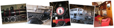
"The Steamtown Heritage Rail Centre is a museum focussing on transportation in a bygone era - particularly Peterborough's narrow gauge railway heritage.  What was once known as the Railway Workshops has now become known as the home of Steamtown situated at the western end of the Main Street. Steamtown's collection includes steam and diesel locomotives and numerous passenger carriages.  The depot turntable is the only three gauge example in the world. The Roundhouse is the last major example of its kind in South Australia.  Historic passenger carriages include fine examples of the cars used on the first transcontinental passenger train to cross the Nullarbor Plain in 1917.  Unique special purpose Vans dating back to the 1880s provide a rare glimpse of times past.  The collection of rare rolling stock includes a 1937 Morris 25 Motor Inspection Car (MIC). The car was converted to operate on narrow gauge track." Reference: Peterborough Tourism Inc

The attached photo album includes views of a First Class carriage with leadlight windows, a lounge and arm chairs upholstered in red leather, a piano and bar, for those with money, they certainly knew how to live in those days!  Also in the album you will find photos of a double-decked sheep/cattle carriage, along with the ramp up to the top deck.  Of particular interest to me was the old 1937 Morris 25, used as a Motor Inspection Car, my Dad had a Morris 14, and he drove us everywhere in it; so, this old Morris bought back lovely memories for me.

If you wish to find out more on Peterborough  and Steamtown, click on the links. I hope you enjoy this posting as much I have bringing it to you. 
View Steamtown - Railway Museum - Peterborough SA
Steamtown, Peterborough SA

Tuesday, July 13, 2010

Burra – Old Copper mining town SA (6 – 12 May, 2010)

I am so glad we chose the town of Burra as the next stop in our journey through South Australia, what a wonderful surprise this town was to both of us. The caravan park we stayed in is a only very tiny, and due to word of mouth from amongst the Grey Nomad set, the place very quickly filled up.  On speaking to other travellers, we discovered most people book for their stay in Burra, in fact we observed many unlucky caravanners being turned way.  Spotlessly clean amenities, friendly managers, and the town is a gem, what more could one ask for. 

Burra, was once a bustling mining area, with the discovery of copper near the Burra Burra Creek in 1845, the town of Kooringa rapidly grew to be Australia's largest inland town by 1851.  All that is left of the mining activities are a lot of ruins, as well as fine examples of the buildings and townships which now make up the village of Burra.  Burra is actually  a collection of townships, each with their own history and buildings to explore.     

Burra Heritage Trail : The town has a Heritage Passport system of key and guide book, which enabled us to discover the many sites of historical interest.  After picking up our keys, we set off to explore. Two places we found of particular interest are listed below: 

First stop was the old dugout homes of the Copper Miners Dugouts.  (1850) The homes were literally dugout of the soft clay banks of the currently dry, and nearly always dry, creek. The first creek dwellings were being dug in 1846, they were favoured by the miners as they were rent free and close to the water. The downside to living along the creek bed was at times it floods; and when it did the waters came with a vengeance.  In 185Burra Cottages (2)1 about 1,800 people out of a total population of 4,400 lived in nearly 600 of these dugouts.  Three floods in 1851 devastated 'Creek Street' (as it was known),  driving the inhabitants from their homes.  By 1860 the dugouts were virtually deserted.  Two dugouts have been preserved by the National trust as a tourist attraction.  Disease was rife amongst the miners and their families and so the government of the day built cottages to entice the people to move out of the dugouts.  A group of some of the houses built for the miners, are displayed in the attached photo.   


  • The Old Redruth Gaol built in 1856 it was the first gaol in South Australia outside of Adelaide.  It provided for thirty prisoners, male and female.  When it closed in 1897, the prisoners being transferred to Gladstone Gaol; it was renovated and opened as a Girls' Reformatory  and finally closed in 1922.  It is now in the care of the National Trust.  In recent years the old gaol has also been the setting for a few scenes in movies, including the trial scene in the Breaker Marrant picture of a few years ago. In the centre of the exercise yard is a toilet - commonly know as a Dunny to those of us in Australia and New Zealand. Any thought of escape over the walls would not be too easy, note the broken glass at the top of the gaol walls!
To view the photos in full view ouside the Slideshow, click  on any picture in the slide show.
Note: the Information on the dugouts and gaol is from the booklet - Discovering Historic Burra - G.J. Drew for the National Trust of South Australia

Monday, July 12, 2010

Nuriootpa SA - Maggie’s Kitchen (2 – 6 May)

After leaving the city of Adelaide, we drove Nth West to the small village of  Nuriootpa. The park we stayed at was small and very clean and within walking distance of the town, and was a good base to explore the area further. However, the main attraction for us staying in Nuri – as the locals call it – was to visit Maggie Beer’s kitchen.
After watching every episode of 'The Cook and The Chef' we had to go out to see where the show was made. Did I mention the other reason was to the opportunity to sample good food? Picnic fare is the order of the day at Maggies place, so we ordered our basket and coffee and sat in the sunshine, we cheated, the sun was coming through the window, and ate delicious pate, bread, olives and dip. Afterwards we went to a demonstration – by Maggie’s daughter – on cooking with Verjuice. Before and after the demonstration, folk are encouraged to wander around the kitchen, open cupboards etc and maybe even play at being Maggie, or being able to cook like her and Simon! Yeah, yeah, I know, in our dreams :)
Anyway, here are a few pictures of Bucko and myself in Maggie's kitchen.

Adelaide Hills etc (19 April – 1 June, 2010)

The next stage in our journey was Adelaide, and on our list of ‘Must See and Things To Do’ etc was:
Seppeltsfield Winery: First stop was a visit to Seppeltsfield for tastings of their wonderful fortified wines. The road into the winery is lined for My Muscatkilometres, with huge palms trees, all planted in the days of the depression, by members of Seppelts staff, to help keep them employed during the tough times. If you follow the link at the beginning of this section on Seppeltsfield, you will see a photograph of the avenue of palms. The Seppelt family no longer own the vineyard or winery, however, the present company keep the history of the place alive, with tours of the old house, and many photographs are hung on the walls. 
Guess what? One of the earlier Seppelt woman had a very unique name – Selma.  A Muscat is named after her, so OF COURSE, I had to buy a couple of bottles, I did taste it first to make sure I liked!  
 Henschke Winery  Paul had been to Henschke Winery many years ago so, we decided to make a visit; of course we only went there to  look at the place, and go out to the old church, how could any of you think otherwise! Naturally, we had our arms twisted to have a tasting, and of course we where bludgeoned into making a few purchases.SA_Gnadenberg Church (3)
The church linked to the Vineyards is a few kms from The Cellar Door, however, as I am interested in old country churches we went for drive to see it. WOW! The outside was very impressive and the trip from the Winery was worth it. I have given you a small taste of the wonderful church. You know the drill, if you would like further photographs of the church, go to Churches Along The Wallaby Track’ Blog.  
  
Hahndorf : One cannot go to Adelaide without taking the trip up to the Hills to the small German style village of Hahndorf, so, we did. Sorry, Dr Pete, we blew the cholesterol issues out the window that day! Pork Knuckle for me and Bucko had a wheel of German sausage, of course Sauerkraut was also on our places.  A walk around the village was definitely in order after that meal, but, did we enjoy ourselves. IMG_1470While wandering the tree lined streets, with footpaths covered in glorious Autumnal coloured leaves, we noticed signs advertising an Anzac Day Dawn Service, to be held in the village on the 25th.    Bucko and I always attend the Anzac Day Daybreak Service at the little Peace Park in Oxford Falls, so this year we observed the Dawn Service in Hahndorf.  After the service, (and as per our family tradition), we had a breakfast of Eggs Benedict and coffee; in one of only 2 places open in Hahndorf at 7.30am.  SA_Kersbrook Uniting Church C1853 (4)
As we had already been up to Hahndorf we decide to take different route back to the caravan park.  The Hills area of Adelaide is so very pretty, and at Kersbrook, I found an old country church, pictures of which will be posted to the ‘Churches Along The Wallaby Track’ Blog 

Lou n Me

Louise Nelson: last but certainly not least, time for me to catch with a very talented lady, Louise Nelson.  I first met Louise at a Scrapbooking retreat at Turramurra, run by Sonia Bowers of Forever Always. The style of Scrapbooking (SB) Louise does, can best be described as eclectic, and to a lot of us Scrapbookers simply stunning , which is too mild a word to describe Louise’s creations.  Why not take a look for yourselves, and click on the following link to Louise's creative art work. Louise and I spent a day doing the rounds of Scrapbooking shops and also had lunch together, a fun day.  I was also very spoilt as Louise gave me a 'Goodie Bag' with lots of wonderful scrapbooking bits and bobs. I am saving them to make a SB page of photos of Lou and myself. Thanks for a fantastic day, Lou.

Friday, July 2, 2010

Goolwa SA – Barrages, keeping the seawater out of the River Murray (16 –19 April, 2010)

While in the small town of Tailem Bend we heard about the Barrages at Goolwa, so decide to spend a few days around the area and see the barrages for ourselves.  The trip from Tailem Bend was very pleasant, we took the ferry over the River Murray to Wellington and then drove down through the picturesque villages along the valley. It was not long before acres and acres of grape vines came into view, lining both sides of the both sides of the roads around Strathalbyn; we were finally getting into grape country. Strathalbyn has a wonderful Lutheran Church which of course I just had to capture photographs for my Blog. Note: those of you who have been reading one of my other Blogs - ‘Churches Along the Wallaby Track’ – the church from Strathalbyn will be posted soon.  If you are interested in country churches, why not join my dear friend Sonia and become a Follower? 

After settling into the caravan park we took off to see the barrages, we had been following the River Murray for such along way, and now it felt terrific to be able to see where the river meets the sea. For those who may be interested, below is information on the barrages. 

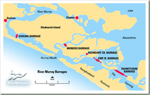
The Goolwa Barrages, (South Australia near Murray Mouth & Coorong), have been constructed in the vicinity of the River Murray mouth, are commonly known as the Goolwa Barrages, and consist of five separate structures with connecting roadways across Ewe Island and Tauwitchere Island.

The main purpose of the barrages at the Murray mouth is to maintain the freshness of the River Murray as far downstream as Wellington. This is an obligation under the Act; and to keep the water at a sufficiently high level to permit the watering by gravitation of the various reclamation areas between Mannum and Wellington. In addition to this, it will prevent the ingress of salt water from the sea during periods of low river, and will help maintain the freshness of the water in Lakes Alexandrina and Albert. Thus ensuring the productivity of the surrounding areas which would otherwise be injuriously affected by salt water after long periods of salinity in the lakes.

image

For those who like more detail, why not read all about the Barrages, the site is very interesting.

Note: All information on the Goolwa Barrages has been copied from : http://www.murrayriver.com.au/river-towns/barrages/

Tuesday, April 27, 2010

Tailem Bend – on the River Murray – SA (13 – 16 April 2010)

We left Robe on Tuesday and at first we took the wrong road, oops, so turned around and were soon on our way again, via Kingston S.E.   Larry The Lobster, (whom we had seen a few days before on our day trip to Kingston, greeted us when we stopped for a Lobster and lettuce sandwich – yummy and coffee, then we  were on our way again.  We had booked into a small caravan park which over looked the River Murray.  As per usual, with some of the less star rated parks what you see is often not what you get.  The BBQ area left a lot to be desired, however, the rest of the place was not too bad. The park is small, with plenty of shady trees, we decided to park near where we could see the river.  Well, due to the long drought the river was actually not where it used to be. A photograph, which was taken 6 years ago, is in the park office, and it showed the water, about 6-10 metres from the base of the cliff, with a causeway through the water to a small island.  Houseboats were moored to landings and others were moored out near the island.  The houseboats are still moored to the landings, but have no way of floating down to the river now that the water has retreated. All, a bit sad when one thinks of how grand The River Murray used to be. Although there have been huge floods up north, including Queensland; and The Channel Country and Lake Eyre have water, none of the it is expected to flow down the river ways to Tailem Bend or the sea; as most of the recent water fall is being stored in huge dams, for the Cotton and Rice growing areas of Queensland and NSW. Talking about storing water, in 1956 there were huge downfalls of rain in Queensland and NSW dams were in danger of overflowing; so the NSW powers that be, decided to release water from the storage area of Meningie Lakes.  The huge volume of water caused a massive flood around the lower reaches of the Murray, especially in Murray Bridge.

Link for more info on Tailem Bend: http://www.murrayriver.com.au/tailem-bend/
IMG_1429_2Wed 14 April - The Big Olive – while in Tailem Bend we went out to The  Big Olive, which is set in a new Business Park on the outskirts of Tailem Bend. The olives are grown near Strathalbyn and processed in Tailem Bend.  A tasting table was set up with various olives and delicious oils, to sample.  Of course we bought oil, as well  as olives.

Link for The Big Olive: http://www.bigolive.com.au/about-us/


Wed 14 April – Murray Bridge – After buying the olives we took off for Murray Bridge, there were a couple of churches I wanted to see as well as have a general look around the town. The first bridge to be built across the Murray is was a rail bridge, and one of the supporting pillars has a notice on it noting the level of the flood in 1956.  An old steam train is also sits dock side, we had to climb on board like the ‘young’ kids we are!  (Click on photos to enlarge)
IMG_5092-a                            IMG_5099

Thur 15 April - Old Tailem Town – Bucko and I being gluttons for punishment, decided to visit Old Tailem Town, an example of what life was like for the settlers of South Australia from 1860 - 1960. We had seen a Pioneer Village when we were in Inverell, NSW, but this one is different. 
Set out in the style of a village, with buildings relocated from their original sites and some of buildings being built onsite, in the style of yesteryear.  IMG_5186In particular a house made out of flatted Tar drums.  When the roads around the area were being built in the days of the depression folks would grab the empty tar drums, have them flatted by the steamroller and then make a house out of them. All the houses and buildings are furnished in keeping with the period of the house.   It was interesting to see how chairs were made out of branches of trees, wire and sacking and beds made with branches of trees for the bedposts. I would not liked to have lived in those days and Bucko and I certainly admire how the pioneers survived in this harsh land. Link to Old Tailem Town:
http://www.oldtailemtown.com/

IMG_5248
IMG_1448  
        IMG_5206

Sunday, April 18, 2010

Robe – SA (7 – 13 April, 2010)

Wed: 7th April  - We arrived in Robe ("as in Robe isn't famous for Robes"), on the 7th April and guess what? Yes, that's right, it rained for 3 out of the 6 days we were there. It actually started to sprinkle as we drove into the town! Ha, ha. Just as well we didn't mind, at least is gave us time to slow down! The trip to Robe (from Mt Gambier)was only 2hrs, and even though we went the coast road, we could not see anything because of the high shrubs and trees. As I never sleep well the night before we go on the road, at least I was able to nod off. Robe is a lovely wee town, heritage buildings mixed with, old beach houses and the more expensive and upmarket, HUGE, glass and timber decked houses. The town has a 'REAL' Butcher who sells fantastic meat; so one night Bucko cooked us a Lamb Roast, with all the trimmings for dinner - Yummy.
Thur: 8th AprilIMG_4990As it was a reasonably clear day, so decided to take off to visit Kingston S.E (the reason for the S.E.? There is another Kingston in South Australia.  Kingston is (according to those who live in Kingston), the Lobster capital of SA, so of course, the town has a BIG Lobster - Larry The Lobster!   Larry is about 30yrs old, according to a man I met while taking the photo, he first saw Larry 30yrs ago.  I am pleased to report Larry appears to be very well looked after, and his colour is true to life.

Old Cape Jaffa Lighthouse - While we were in Kingston we discovered the old Cape Jaffa Lighthouse was open to the public.  As I am rather taken with lighthouses, we decided to climb the steep stairs, and go inside.  Bucko was as happy as me to be able to actually see inside a Lighthouse; even though it is no longer in use, and it is on land.  The lighthouse was built between the years of 1868 – 1872, and used to sit out on a platform on the Margaret Brock Reef, (the reef was named after a sailing ship), 15kms out to sea and was relocated to land during 1975-76.  The following italic component of this posting, is an excerpt from Lighthouses of Australia  website: http://www.lighthouse.net.au/lights/SA/Cape%20Jaffa/Cape%20Jaffa.htm  “This type of lighthouse is known as "Wells Screw Pile" and was selected for this location because the narrow wrought iron piles offered the most resistance to the heavy seas that break across the reef.  All the parts for this lighthouse were manufactured and pre-assembled, in England then dismantled and shipped to Australia.  Extreme difficulties were encountered during its construction which took 3 years instead of the proposed 1 year.  Apparently when the site was first chosen the sea and weather was unusually calm. When it came time to construct the lighthouse seas were wild and the weather rough. Early construction was washed away and sometimes the contractors could not go out for days.”  The website has photos of the Lighthouse when it was in situ as well as the Gannet Rookery.  All the photographs listed in the album were taken by myself. 
The lighthouse is now a property of The National Trust of Australia.  The Keeper would have to manually wind the light so it would turn, (the light operates on similar mechanism as a Grand-father clock); so up and down the stairs he would climb each hour during the night to keep the light shining. Initially the Lighthouse Keeper and his family lived out in the lighthouse, and would return to land when his term of duty was up; they would then be replaced by another Keeper and his family. At one stage, due to a severe storm, there were two families living in the lighthouse.  For about a month, a total of 11 people were living in the very small rooms until the bad weather was over!  I can only start to imagine the horror of it all.  Storms raging outside and in with various personalities, and children, how did they all cope?  The women had it very tough. Cooking was done on a small kerosene stove and oven. The washing was scrubbed on a scrubbing board, then put through a mangle to remove the bulk of the water, and finally strung outside to dry on a very small line, attached to one of the walkways around the lighthouse. I bet they lost a few items of clothing, by the washing being blown away.  To go to the toilet, one had to climb down the main outside stairs, walk along a narrow steel walkway, (all the time making sure one was holding onto the rail), then as was one nearly reached the loo, the rail was no longer there - eek! Someone in their wisdom, set the toilet about 1 metre away from the railing!  How scary. Eventually, three houses were built for the three Lighthouse Keepers and their families, so the women and children no longer had to go out to the reef. Imagine trying to bring up children in such a confined and frightening environment, it would be tad difficult to tell the kids to go outside and play! I am sure the house on land came as a very welcome relief for the mothers, and peace of mind would possibly have reigned at last. IMG_4928

The Cape Jaffa Lighthouse platform now has an automatic beacon sitting where the lighthouse used to be and is also a wonderful home to a colony of Gannets; all the side rails and ladders have been removed so that folk are not tempted to climb onto the platform.

The town of Robe is now home to a new and boring contemporary lighthouse, with a feeling no where near as romantic as the old Cape Jaffa Lighthouse.

IMG_5503
Craft Work - Now, for the Crafty women in my life.and I mean that in the nicest possible way. I found a Patchwork Shop, and yes, I did buy some material and batting!  When I was in New Zealand last, I bought a piece of material to make myself a small quilt, to keep me occupied during our travels.  I am taking the easy way out, and using the whole piece of material, I will add the batting and backing, and will then quilt in between the faux patches.  The pattern on the material is representative of the many types of weaving found in Maori Meeting Houses.  Bucko has a good eye for colours, and chose the backing and border material.  
Click on View Full Album to see all the photos. – enjoy.